First Fog Water Map Created in Chile
A free interactive platform reveals how much water can be extracted from the coastal camanchaca in the north and center of the country, opening new possibilities to face the water crisis. The project is the result of long-standing scientific research led by UC Chile, through the UC Chile Atacama Desert Center (CDA, as per its Spanish acronym) in collaboration with the UC Chile Law and Water Management Center (CDGA, as per its Spanish acronym) and joint work with public institutions such as the General Water Directorate of Chile, the Chilean Ministry of Public Works and the Chilean Ministry of National Assets.
photo_camera As explained by the director of the UC Chile Atacama Desert Center, CDA, Camilo del Río: “This tool seeks to be an input for decision making regarding the use and management of this complementary water source as well as water resources in Chile”. (Photo credit: Nicole Saffie)
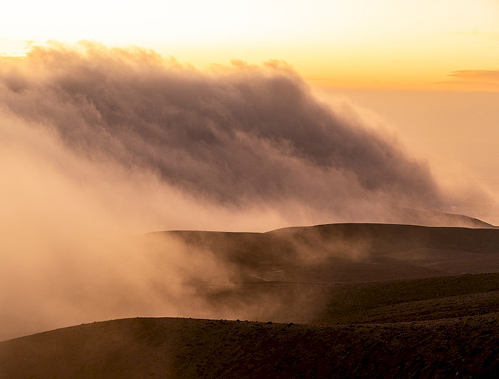
Every morning, a truly thick blanket of fog covers the coastal cliffs of northern Chile. It slips through the desert vegetation, envelops the hills, and disappears with the first rays of the sun. Today, thanks to a digital platform whose origins date back to long-standing research by the Atacama Desert Center and the Institute of Geography, both from UC Chile, this morning's mist can be converted into a quantifiable, mappable, and usable source of water.
This is the Fog Water Map—publicly launched on June 2 by the UC Chile Atacama Desert Center—the first interactive viewer that allows users to explore the water potential of the camanchaca along 2,000 kilometers of Chilean coastline, from Arica to Maule. The platform, which is free and open to the public, not only shows where fog occurs, but also reveals how much water can be extracted from it, meter by meter, month by month.
"It is estimated that 72% of Chile's surface area suffers from drought to varying degrees. This shocking fact is not new and highlights the urgency of finding solutions to the water crisis in various parts of the country. That is why we are here today to learn about the initiative that seeks to address water scarcity in Chile," said Valeria Palanza, dean of UC Chile's Faculty of History, Geography and Political Science, during the presentation of the initiative.
As Camilo del Río, director of the UC Chile Atacama Desert Center and one of the researchers who has led the project, explains, “the fog water map is an interactive platform that makes information about potentially collectable fog water for the coastal territories of northern and central Chile (18° and 35°S) available to the general public free of charge.”
He adds that "it also provides governance and regulatory information related to the collection and use of fog water. This tool is intended to be an input for decision-making regarding the use and management of this complementary water source and water resources in Chile."
The Fog Water Map is a free, publicly accessible platform that not only shows where fog is present but also reveals how much water can be extracted from it, meter by meter, month by month.
As Virginia Carter, assistant professor at the School of Government and Public Administration at Universidad Mayor and associate researcher at the UC Chile Atacama Desert Center, explains, "the fog map provides data on the potential for collection and allows it to be visualized spatially, which is extremely relevant so that, for example, local governments have that information at their disposal when drawing up and updating their regulatory plans, estimating areas of urban growth or industrial location, etc." She adds: "It will always be better to have more information to contribute to decision-making, which will lead to better development of the territories."
AMARU: The water snake that deciphers the clouds
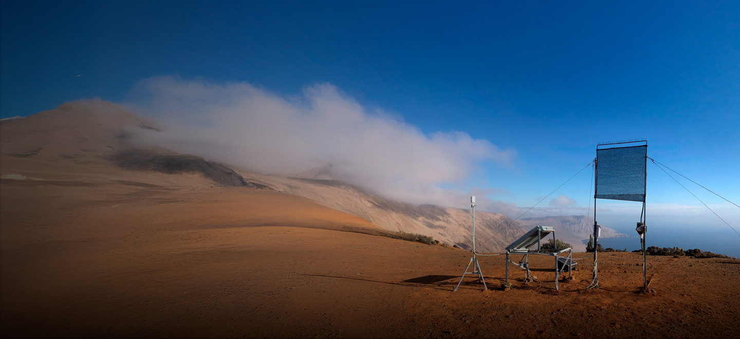
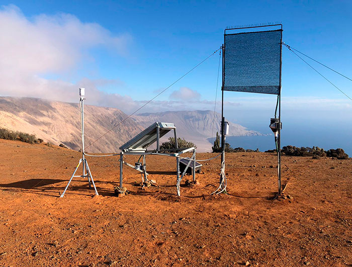
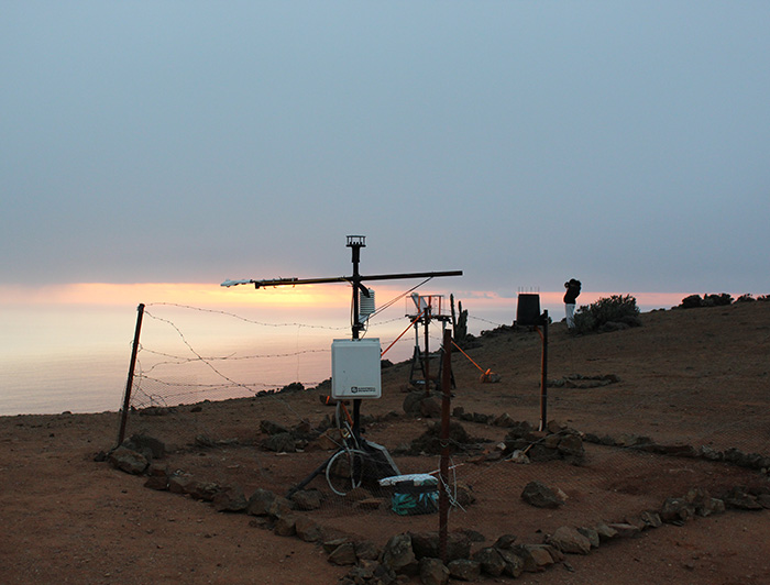
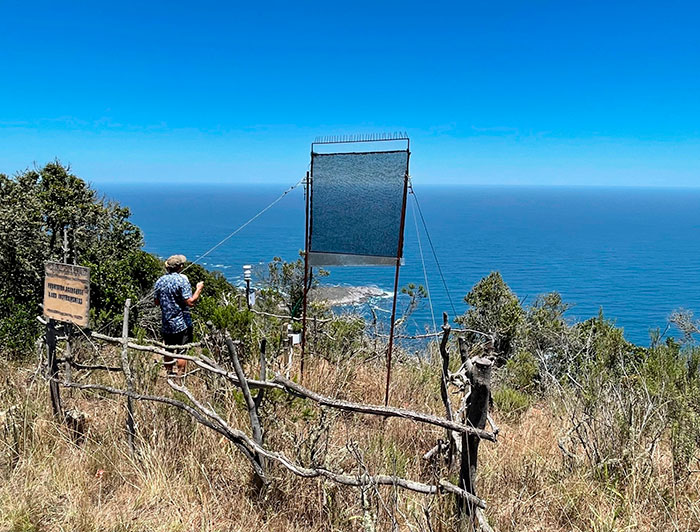
“We have been researching fog for decades, but all our knowledge did not necessarily reach those who manage water resources,” explains Camilo del Río, professor at the Institute of Geography, an academic unit that has been a pioneer in the study of fog water, primarily through the UC Chile Atacama Station—part of the Network of Centers and Field Research Stations (RCER UC, as per its Spanish acronym )—where the longest-running continuous fog water measurements in Chile are carried out, conducting extensive research, teaching, and community outreach. He adds: “What was missing was reliable and easily accessible information, where anyone could find out where, when, and how much fog water they could collect.”
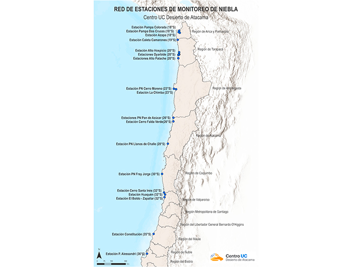
The technological heart of the project has a poetic name: AMARU, which in Quechua means “water snake,” about the ancient Inca god associated with desert rains. The metaphor is accurate: the marine stratocumulus clouds that produce fog form a long belt of water that winds along the Chilean coast. This computational model represents an unprecedented methodological innovation. It is based on physical principles of mass conservation and thermodynamic changes in humid air masses, drawing on meteorological observations from more than 25 stations distributed between the regions of Arica in the north and Maule in the south-central part of the country. The system integrates real-time atmospheric data, GOES satellite images, and digital elevation models to generate accurate maps of the fog's water potential.
As Camilo del Río explains: "One of the major limitations to the use of fog water in Chile, or at least to its consideration in water management, is the lack of reliable information that would allow us to evaluate whether it is an alternative or complementary source for territories and communities with water shortages. This is how the idea was born to transfer years of research and advances in our understanding of fog or camanchaca, most easily and educationally possible through a spatial viewer, where the answers to key questions such as “Where are the areas with collection potential?”, “When and how much water can I collect?” can be found.
The result goes beyond traditional estimates: it not only reveals where fog is present, but also quantifies the amount of water that can be extracted per square meter of land. This is achieved through a model based on atmospheric data, satellite imagery, and digital elevation models. The model is integrated into a platform that brings together all spatial information, along with various supporting data on fog water collection and use.
However, the model's scope extends beyond Chile's borders and has the potential to be replicated in other arid ecosystems worldwide where fog is present. “The model represents fog collection in advective fog environments, such as those found in Chile, Peru, California, Namibia, Portugal, Spain, and Morocco,” explains Felipe Lobos, a researcher at the UC Chile Atacama Desert Center and professor at the UC Chile's Faculty of Agricultural and Natural Systems, who developed the model. “To use it in these areas, only meteorological data is needed. We have currently begun collaborations with academics from the University of California, Santa Barbara, to test the model on Santa Cruz Island in California.”
The platform offers multiple layers of information:
- Accurate technical data: Annual and monthly potential for water collection per square meter, frequency of fog occurrence, interannual variability of the phenomenon, and optimal areas for fog collection installation.
- Legal framework and governance: A regulatory assessment prepared by the UC Chile Law and Water Management Center, (CDGA, as per its Spanish acronym) on the regulation of fog water in Chile, which is currently in a legal gray area under Chile's Water Code.
- Interactive education: An educational tour explaining how fog is formed, how its collection is measured, what instruments are used, and how the Fog Monitoring Station Network operates.
- Real cases: Specific experiences where fog water has been used successfully, from fishing villages to unique ecosystems.
Direct impact on communities
The project is a concrete tool that improves people's quality of life by providing water for both consumption and productive activities.
In Alto Hospicio, in the Tarapacá region, with 110,000 inhabitants and located in the middle of the Atacama Desert, in an area where annual rainfall averages 0.9 mm—that is, it practically never rains—the map identifies areas where it is possible to collect 3 liters per square meter per day. For a city that still depends on water trucks on its outskirts, this information represents an unprecedented opportunity for urban planning and improving people's quality of life.
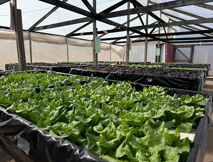
In Chañaral, in the Atacama region, the Agrupación de Atrapanieblas (Fog Catcher Association) has been operating a successful system in the town of Falda Verde since 2001. Artisanal fishermen not only solved their basic water needs but also developed aloe vera crops, fish farming, and, more recently, lettuce and strawberries, demonstrating the economic potential of the resource.
The fishing villages south of Iquique—where nearly 1,000 people live in settlements such as Riquelme and Chanavaya—exemplify how the map can inform sustainable territorial development strategies.
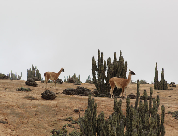
Fog: a source of life for ecosystems
The map also reveals the ecological importance of the camanchaca. In Alto Patache, a fog oasis managed by UC Chile since 2007, endemic species have evolved to depend entirely on atmospheric water, creating one of the richest ecosystems in northern Chile.
In Pan de Azúcar National Park, cactus communities such as Copiapoa grandiflora obtain water and nutrients exclusively from fog. In Fray Jorge, areas of forest with endemic tree species, which resemble those found in the Valdivian rainforest of southern Chile, survive amid the semi-desert thanks to the camanchaca, demonstrating how this phenomenon has been able to sustain entire ecosystems.
Redrawing the water future
The Fog Water Map transcends its immediate application. The data generated opens up possibilities for research in climatology, meteorology, ecology, and energy. The AMARU model can be adapted for use in other arid regions of the world, making the Chilean project a global benchmark.
For the first time, information that was previously restricted to specialized academic circles is now freely available to anyone. Farmers, urban planners, conservationists, and entrepreneurs can now make informed decisions about the use of this atmospheric resource.
As Virginia Carter states, "communities that currently live in water-scarce areas and are located near potential catchment areas could also benefit, because with this information they could explore potential catchment in their territory, carry out an assessment, and evaluate the implementation of productive activities, for example; they could also look into the possibility of subsidies at the regional or even community level, or even international sources of financing."
For his part, the Director General of Water, Rodrigo Sanhueza, said at the launch of the platform that given the worrying drought situation in Chile, "the Agua de Niebla map is precisely one of these solutions, which may be local solutions, but can perfectly well enable people to develop in these sectors and also avoid other consequences of the drought. This is not just a matter of not being able to turn on the tap or having a certain amount of water in our homes, but of consequences such as the displacement of many people who live in a sector and will have to migrate to where they can count on drinking water for their subsistence."
In turn, Sofía Nilo, executive secretary of IDE Chile (Geospatial Data Infrastructure) at the Chilean Ministry of National Assets, said, "This data will not only contribute to the decisions we make about where to invest or where we can extract (water) resources for certain localities or communities, but also to studying how it is affecting our country. This information is extremely valuable in every sense. Also, because this information is available to the academic community, but also to the community in general, and public organizations."
As Camilo del Río concludes: “We hope that fog water will be truly considered in our water management, that the map will be a key input for decisions regarding which water source to use in areas where fog is an alternative.”
In a context of climate change and increasing water scarcity, the Chilean project offers an innovative approach that recognizes the value of unconventional water sources. The camanchaca, which for millennia was simply part of the landscape of the northern and central coast of the country, now emerges as a resource with transformative potential for communities and ecosystems that have learned to survive on the margins of what is possible.
The FONDEF IDEA R&D project “Fog Water Map (18º-35ºs): Model of availability and governance of a complementary source for water-scarce territories” represents a model of interdisciplinary research that integrates science, law, and public policy. This platform is the result of rigorous scientific work led by the UC Chile Atacama Desert, in collaboration with the UC Water Law and Management Center, the Chilean General Directorate of Water, the Chilean Ministry of Public Works and the Chilean Ministry of National Assets. This alliance was crucial, as new legal and institutional frameworks are required to regulate and standardize fog water. This is the first step in moving in that direction, making this public resource available.


