What Are the Mysterious Zebra Stripes of the Atacama Desert?
A team led by researchers from the University of Cologne in Germany and the UC Chile is seeking to uncover a unique geomorphological phenomenon: distinctive bands of stones that descend the arid slopes of the Coastal Mountain Range in the Antofagasta Region, Chile. Understanding their origin and evolution will help reconstruct the geological past of our planet, especially in the most arid areas of the Earth.
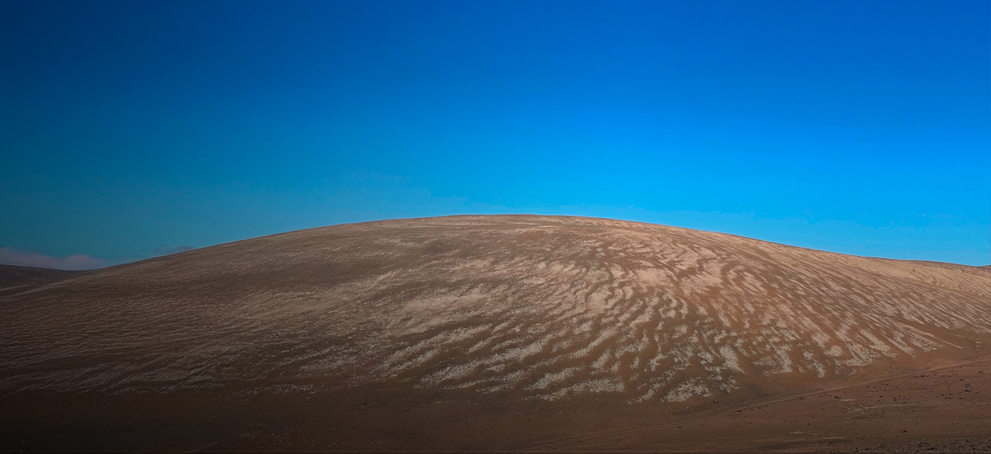
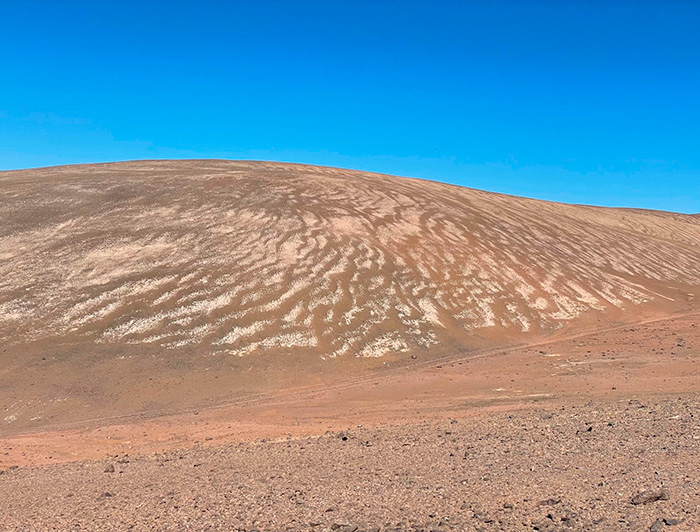
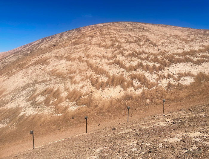
photo_camera A panoramic view of "zebra stripe" formations on the arid slopes of the Atacama Desert. These distinctive geological patterns show orderly bands of stones that resemble zebra stripes as they descend obliquely down the hills. (Photo credit: Juan Luis García)
On the arid slopes of the Atacama Desert in Chile, a unique geomorphological phenomenon has puzzled scientists for almost a century. Just a few kilometers from the Pacific Ocean but more than 2,000 meters above sea level, the slopes are decorated with ordered bands of stones resembling zebra stripes. These formations, known as "zebra stripes," represent one of the most fascinating enigmas of the Chilean desert landscape and are the subject of a challenging international research project.
The Slow Pulse of the Desert
When the desert sun strikes the steep slopes of the Coastal Mountain Range at just the right angle, near the Paposo area in the Antofagasta Region, the shadows reveal a striking pattern: ordered bands of stones descending obliquely down the slopes, showing a geometric pattern that draws the attention of any observer.
These formations are not random. The bands are composed of clasts (rock fragments), meticulously arranged according to size, with the smallest at the back and the largest at the front of each stripe, as if migrating downhill. They can be positioned perpendicular, subparallel, or obliquely to the slope, creating a visual effect that has attracted the attention of scientists since they were documented in 1927 by German researcher Hans Mortensen.
“The term ‘zebra stripes’ is more of a nickname, a practical term we use to refer to this very particular pattern,” explains geomorphologist Juan Luis García, professor at the Institute of Geography and researcher at the UC Chile Atacama Desert Center (CDA, according to its Spanish acronym).
The academic is participating in an international project led by Simon Matthias May and Lucas Ageby, both professors at the Institute of Geography at the University of Cologne, Germany, which seeks to understand how these stripes form in an environment where geomorphological processes advance extremely slowly.
Contrary to the popular perception of the desert as a static and immutable environment, the most recent research suggests that the Atacama landscape is "alive." However, its pulse is measured in millennia. "We believe there are significant, more frequent, one-off events that generate changes in the desert's landforms, such as the 'zebra stripes'," explains Juan Luis García.
This project seeks to understand how these stripes form in an environment where geomorphological processes advance extremely slowly.
Preliminary data and the dating of "zebra stripes" at a nearby site, carried out by Owen et al. (2013), suggest that the clasts of the bands have been exposed at the surface for over a million years. Paradoxically, however, they are not fossils from a distant past: “The clasts, and perhaps the bands themselves, seem to have covered the slopes for over a million years, but that doesn't mean they haven't moved in a million years,” says Professor García, highlighting the exceptionally slow surface processes and the fascinating duality between age and dynamism.
Possible Answers to a Geological Mystery

The causal origin of the "zebra stripes" remains a matter of debate, and several hypotheses currently exist that attempt to explain how these bands of organized clasts formed. Each hypothesis contributes a different piece to a geological puzzle that still awaits resolution with new research, such as the one currently being conducted.
One of the first ideas was water flows: ancient floods in the form of sheet runoff—not channeled torrents—that would have covered the slopes like a blanket of water and sediment, organizing rock fragments in their path.
Another proposal alludes to freezing and thawing. In winter, temperatures can drop sufficiently to freeze the ground temporarily. As the soil thaws, this cyclical freeze-thaw movement can slowly push the clasts together to form the observed patterns, a process similar to that of periglacial terrain in colder regions.
These formations could be due to the humidification and drying cycles of the soil, which is rich in gypsum salts. This mineral can absorb moisture from the sea air, expand, and then contract upon evaporation, cracking the soil and potentially causing the stones to disperse gradually over time.
Finally, the similarities with deposits resulting from dry granular flows also suggest a possible contribution of seismic activity to the formation of the zebra stripes (May et al., 2019). However, none of these hypotheses can be rejected or verified so far, and it is possible that all of these processes, along with additional factors such as wind, contribute to the formation of the zebra stripes. This potentially complex formation mechanism is what the project aims to explain.

Cutting-edge technology to detect imperceptible movement
To solve this enigma, in 2024, the German Research Foundation (DFG) approved a project entitled "Key Mechanisms and Chronology of geomorphological processes in hyperarid landscapes." This study, led by Simon Matthias May and Lucas Ageby of the University of Cologne, includes the participation of Juan Luis García as a research associate at the UC Chile's Atacama Desert Center (CDA).
"Geomorphological processes under extreme hyperaridity are poorly understood, and their rates are largely unknown," explains Juan Luis García, adding: "This project is specifically focused on studying the processes, drivers, and timescales of sediment production and transport on slopes in hyperarid landscapes, investigating the so-called zebra stripes."
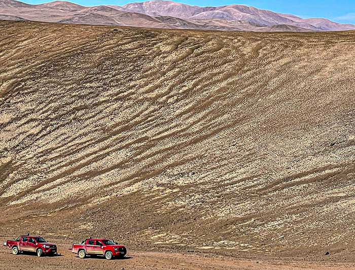
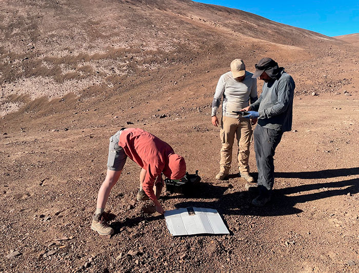
The team of researchers has deployed a veritable technological arsenal at three key sites in the Coastal Mountain Range. According to Professor García, the idea is "to tackle this geomorphological problem with all possible tools, to test existing hypotheses and open up new possibilities."
At each location, multiple cameras capture continuous images that, using aerial photogrammetric techniques, could reveal movements imperceptible to the human eye. In addition, flying drones are tasked with creating detailed 3D maps, while meteorological stations located at each location monitor atmospheric conditions in parallel.
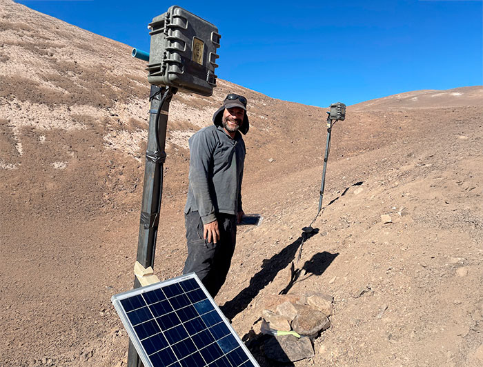
At the same time, advanced dating techniques such as Optically Stimulated Luminescence (OSL) will be used, which will determine whether the clasts rotate as they move. In contrast, cosmogenic isotope dating (beryllium-10) will help establish the general chronological framework of the formations. The academic explains that these samples will be used in the Cosmogenic Isotope Laboratory, which he directs at the Institute of Geography, to prepare and generate the dates.
"After our first recent fieldwork, we will return to download the camera data, conduct another drone survey, and take more samples," the researcher explains about the next field campaign scheduled for September-October of this year when the Southern Hemisphere winter—potentially a critical period for the dynamics of these formations—is ending. "It would be great if we found some clues and tested our hypotheses."
"This project is specifically focused on studying the processes, factors, and timescales of sediment production and transport on slopes in hyperarid landscapes, investigating the so-called zebra stripes," says Juan Luis García, professor at the Institute of Geography and researcher at the UC Chile's Atacama Desert Center, CDA
A Journey to the Past and Future
Although it is still uncertain when their formation began, the "zebra stripes" of the Atacama Desert may have witnessed more than a million years of Earth's history. Therefore, they could have persisted as species evolved and became extinct and as the global climate oscillated between glacial and interglacial periods. But these ancient formations are not static; they represent a dynamic process that continues today, albeit at a pace that escapes our perception of time. "The hypothesis is that they are moving, and we want to detect it," says Professor Juan Luis García.
Understanding their origin and evolution enables us to reconstruct our planet's geological past, particularly how landscapes evolve under extreme aridity, without any apparent role for biological activity, limited by the extreme conditions of deserts like the Atacama Desert.


